Application
We cooperate with local developers to provide industrial solutions for customers.


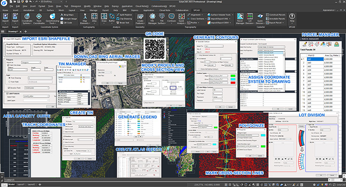
SPCAD is the first of a series of custom CAD-based applications, launched through the platform CADOMATION - an all-inclusive platform offering customized solutions to multi-disciplinary CAD professionals to accelerate the CAD design process by automating loopy and time-taking routine functions.
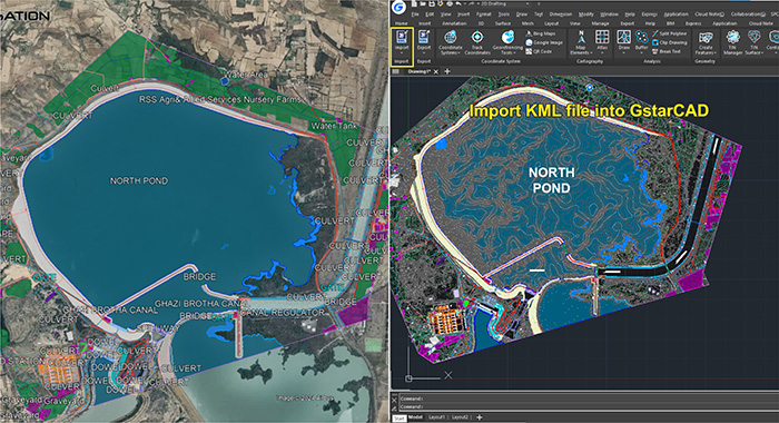
SPCAD allows you to seamlessly import a variety of file formats such as KML, Shapefile, CSV, GPX, LAS/LAZ, raster images, GeoJSON, and XYZ, while also enabling efficient export to formats like KML, Shapefile, GeoJSON, CSV, GPX, KMZ, and more. Manage coordinate systems with the ability to assign/unassign, display information, change drawing units, and convert values across different projected coordinate systems. Apply transformations, grid-to-ground conversions, and incorporate QR codes for precise coordinate values. The cartography features facilitate the insertion of North Arrow, Scale bar, Legend, and symbols, along with the creation of data-driven sheets and callouts for diverse locations. Topography tasks are streamlined with tools for defining alignments, marking chainages, creating TIN surfaces, contours, and elevation points. In cadaster operations, Parcel Manager simplifies tasks like creating, adding, locating, labeling, and organizing parcels, as well as enabling lot subdivision and division methods. Analysis capabilities include cutting and merging closed polylines, creating buffers, displaying line and block information, and handling various geometry tasks such as creating right-angled triangles and converting 2D to 3D polylines. The comprehensive suite also allows for reducing nodes from a polyline and managing blocks with Block Manager. From assigning coordinates system to your drawing to importing/exporting geospatial files, to performing topographic analysis and creating maps and cadaster plans, you can now run spatial analysis without switching to a different software. Specifically designed for geospatial analysis, SPCAD ensures GstarCAD users experience enhanced efficiency and convenience in their workflows.
Explore our Tool bundles to find the tool apt for your needs:
Import & Export:
Import in Drawing:
• KML file
• Shapefile
• CSV file
• Text file
• GPX file
• LAS/LAZ file
• Raster images with world file
• GeoJSON file
• XYZ file
Export Drawing to:
• KML File
• ShapeFile
• GeoJSON File
• CSV File
• Block to CSV
• GPX File
• KMZ File (for images)
• Text File
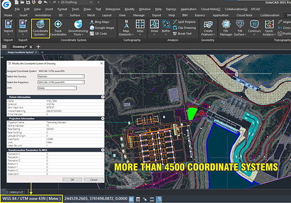
Coordinate System:
• Assign/Unassign Coordinate System and display Coordinate System Information
• Bing Satellite Imagery
• Track Coordinates in Real-Time
• Georeferencing Tools for Accurate Raster Adjustments
• Import Google Image Directly into CAD
• Generate QR Codes for Coordinate Values
• Convert Coordinate Values for Different Projected Coordinate Systems
• Apply Grid-to-Ground Conversions
• Calculate Geodetic Distance and Scale Factor
• Apply Custom Transformations for Precision Mapping
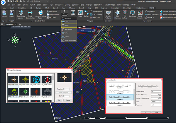
Cartography:
• Insert North Arrow, Scale Bar, Legend in the Drawing
• Place Symbols on Coordinates Categorically
• Create Data-Driven Sheets for Linear Features and Areas
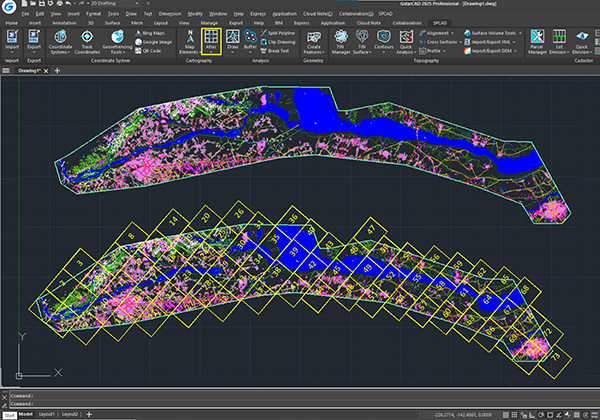
• Create/Delete Atlas PDFs
• Add Callouts for Different Locations
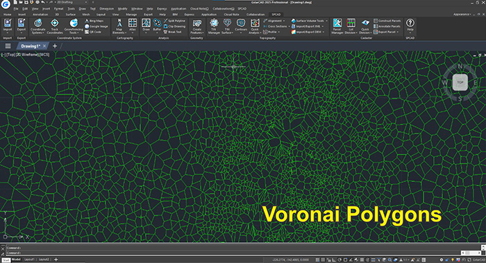
Analysis:
• Generate Voronoi Polygons for Area of Influence Analysis
• Create Boundaries Around Points for Spatial Analysis
• Create Buffers Around Points, Lines/Polylines, and Closed Polylines
• Cut and Merge Closed Polylines (Polygons)
• Clip Drawing
• Break Text (Split Sentences into Words)
Geometry:
• Polygonize: Convert Crossing Lines/Polylines/Arcs into Polygons
• Create Right-Angled Triangle, Three-Point Rectangle, Angle Bisector, Box Around Text
• Convert 2D to 3D Polylines
• Convert 3D to 2D Polylines
• Reduce Nodes from a Polyline
• Convert Circle, Arc, and Spline to Polylines
• Delete Blocks with Block Manager
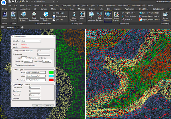
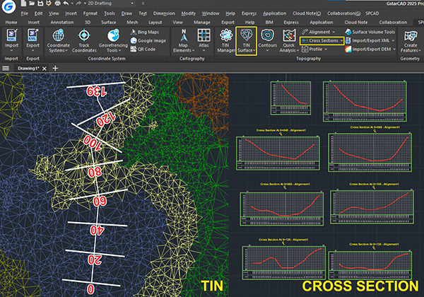
Topography:
• TIN Manager to Manage Multiple Surfaces and Run Advanced Tools
• Create TIN Surface from Points
• Merge Two TINs into One Seamlessly
• Generate TIN from Contours for Detailed Surface Analysis
• Project Features to TIN Surface for 3D Accuracy
• Convert External TINs to SPCAD TINs for Advanced Analysis
• Quick Analysis: Rapid Contours, Cross Sections, and Profiles
• Create and Label Contours
• Define Alignments and Mark Chainages Along Alignment
• Mark Cross Sections and Generate Longitudinal Profiles with Ease
• Surface Volume Tools: TIN Comparison, Surface Volume, and Area-Capacity Curve Calculation
• Import/Export LandXML and DEM Files into CAD
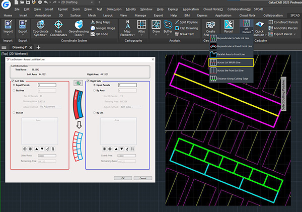
Cadaster:
• Parcel Manager to Organize Land Parcels Efficiently
• Lot Division – 6 unique and advanced methods for Subdivision
• Quick Division for Fast Parcel Management
• Construct Parcels with Custom Criteria
• Annotate Parcels for Cadastral Mapping
• Export Parcels to Table, SHP, KML, and CSV
SPCAD Essentials:
• Online Help Documentation for Easy Learning
• License Management for Hassle-Free Activation
• Software Updates to Keep Features Up-to-Date
• Language Switching for a Personalized Experience