Application
We cooperate with local developers to provide industrial solutions for customers.


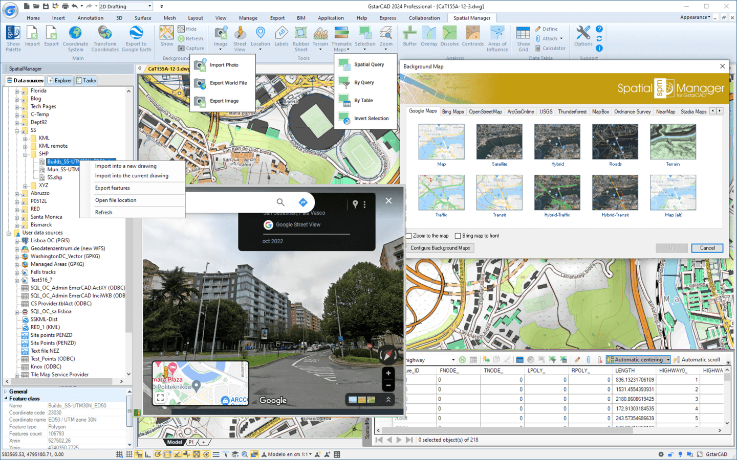
Spatial Manager™ for GstarCAD comes in a lightweight application that runs inside GstarCAD and allows the user to import and export geospatial data between GstarCAD drawings and geospatial files, data servers or data stores, display background maps, manage alphanumeric data and data tables, create terrain models and contours, search for locations, transform coordinate systems, and many more geospatial functionalities.
• Import spatial data into GstarCAD*: Imports spatial data, into new or existing GstarCAD drawings, as GstarCAD objects and Extended Entity Data (EED)
• Export spatial data from GstarCAD*: Export objects from the drawing to spatial files or databases, and saves their Extended Entity Data (EED) as alphanumeric data tables
• Coordinates transformation: Calculate geometric transformations of the objects in the import and export processes
• Transform drawings Coordinate System: Transform the Coordinate System (CRS) of a whole drawing or a set of selected objects
• Background maps: Choose from among a lot of dynamic Backgrounds Maps from providers such as Google Maps, OpenStreetMap, Bing, MapBox, Ordnance Survey, etc., or configure your own maps from TMS, WMS or WMTS servers
• Publishing to Google Earth: Export all or part of the objects in the visible Layers of the drawing and their data to a KML or KMZ file
• Thematic maps: Visualize objects coloring them depending on their field values
• Data management, query and edition: Manage the alphanumeric data attached to the objects, design and edit the structure which will be used to store the data
• Data grid: The Data Grid palette allows you to view, edit, etc. the objects data in any table in the drawing. You can also select objects from the Data Grid, export the data from the tables and more
• Fields calculator: Calculate simple or complex expressions using operators and functions that can be applied to field values in a table and/or to constant values
• Spatial analysis: Perform spatial analysis operations over the objects in the drawing generating new objects from such analysis
• Location tools: Location and geo-coding tools help to add reference elements and enhanced data to existing objects
• Google Street View integration: Google Street View dynamic image browser on any geo-referenced drawing or map
• Label objects: Label data values from tables attached to the objects as Texts
• Terrains: Create Terrains and other related objects (3D Points, Contours, etc.) from 3D data or from Elevation services
• Import tasks: Save Tasks to replay import processes (including all process parameters) so many times as desired
• Multilanguage: Available in English, German, Spanish, French, Russian and Portuguese
• Perpetual license: Pay once, no periodic fees
Available data providers:
• Spatial files
o Esri Shape file - (SHP)
o Google Earth file - (KML, KMZ)
o OpenStreetMap file - (OSM, PBF) (1)
o LiDAR file - (LAS, LAZ) (1)
o GPS exchange format file - (GPX)
o Esri ASCII Grid file - (ASC, ASCII)
o ASCII text file - (ASC, CSV, NEZ, TXT, XYZ, UPT)
o SQLite file - (SQLITE, DB)
o GeoPackage file - (GPKG) (1)
o GML file - (GML, GZ, XML)
o Raster image file - (TIF, PNG, JPG, JPEG, TIFF) (1)
o Autodesk SDF file - (SDF) (3)
o MicroStation v.7 file - (DGN) (2)
o AutoCAD DXF file - (DXF) (2)
o Esri ArcInfo export file (ASCII) - (E00) (1) (2)
o MapInfo file - (TAB) (2)
o MapInfo interchange format file - (MIF/MID) (2)
o GeoJSON file - (GEO.JSON) (2)
• Spatial raster files
o Raster image file - (TIF, PNG, JPG, JPEG, TIFF) (1)
o Georeference sources - (GeoTIFF, World files, Google Earth .GEPRINT, etc.)
• Spatial data servers
o Esri Geodatabase File (1)
o PostGIS database
o Microsoft SQL Server Spatial database
o MySQL database (1) (3)
• Image map servers
• WMS Web Map Services (4)
• WMTS Web Map Tile Services (4)
• XYZ/TMS Tile Map Services (4)
• Other spatial data sources
• Open Database Connectivity ODBC (1)
• WFS data store (1)
• WFS data store (FDO) (1) (3) (5)
• WFS data store (OGR) (1) (2) (5)
(1) Read-only
(2) OGR data source
(3) FDO provider
(4) Background Maps technology
(5) DEPRECATED - Whenever possible use the native WFS data provider
• Note: certain data Providers are only valid for some Editions of the application